
2026 REUNION, Rockport, MA
LAST CHANCE, REGISTER BY JUNE 15th!
If you need to cancel your Rockport Inn & Suites hotel reservations, do so by May 31st!
Click here for a Souvenir Map of Salem!
Situated on scenic Cape Ann, Rockport is world-famous as an art colony and oceanfront retreat where vacationers sunbathe or hike and birdwatch at Halibut Point State Park. Stroll Bearskin Neck, with its variety of antique stores, jewelry shops, clothing boutiques and other shops! With one of the most picturesque harbors in the nation, Rockport is the epitome of quaint, New England charm. See Motif No. 1, the red, harbor-side fishing shack that is one of the most-painted (and photographed) buildings in the world. Cape Ann offers the perfect opportunity for whale watching, because they come here to feed in summertime. Many whale boats guarantee sightings, we recommend Cape Ann Whale Watch.
Nearby, Gloucester was the setting for the movie "The Perfect Storm," a drama depicting the fishermen who go down to the sea, risking their lives to bring us their catch. It is where the Dorchester Company first established their fishing camp in 1623, only to abandon it a few years later. Their saltmaker, Roger Conant led the survivors to Naumkeag and continued operations as 'govenor' until the arrival of the Puritans in 1628. The Puritans renamed it Salem and displaced Roger and the other "Old Planters" by granting them land in Beverly where their descendants became the neighbors of our Philip and Martha when they settled in 1698. Gloucester's Dogtown neighborhood was the birthplace of Roger Babson, the financial wizard who developed Babson Park, where our Lindus Cody's family built Cody Villa. Gloucester has a colorful history, symbolized by the annual 'Greasy Pole' contest!
Nearby, Salem is the North Shore's most popular tourist destination! It was the first town founded by the Puritans and the location of the infamous Witch Trials of 1692. Our Philip and Martha lived at Philip English's 'Great House' in Salem, until they bought their Beverly Homestead in 1698. Mostly, the tourist trade caters to the Witch Trials and other supernatural themes, but the Peabody-Essex Museum is truly a marvel for family-friendly art and history. Salem has a wealth of things to see and do!
Of course, Boston will be hosting thousands of tourists and presenting many special events to commorate the USA's 250th Anniversary. We recommend Fenway Park, the Freedom Trail, the Duck Boats, the Swan Boats, the Aquarium and the New England Historical Genealogical Society's 'Family Heritage Experience' for your appreciation. Further south, there is Plimoth Pawtuxet Museums, where a full-size replica of the Mayflower is docked, plus an entire village, populated with historical interpreters who portray the Pilgrims' daily lives.
If you take pictures or videos, we can make arrangements to share them with the stay-at-homes by publishing them on our website or in the Review!
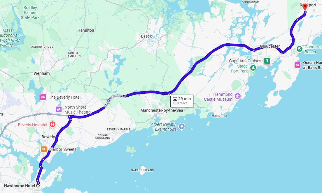
Make your own plans to travel to Rockport. If you're flying, Logan International Airport (BOS) is serviced by all the major airlines. Manchester-Boston Regional Airport (MHT) in New Hampshire and T. F. Green International Airport (PVD) in Rhode Island are two alternatives.
Take the "T" from Logan to Boston’s North Station for commuter rail service to Rockport.
We recommend renting a car at the airport and driving the 40 miles to Rockport. The car will come in handy because we'll be driving to most of the activities.
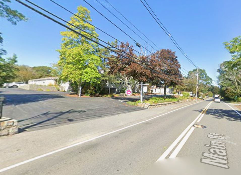
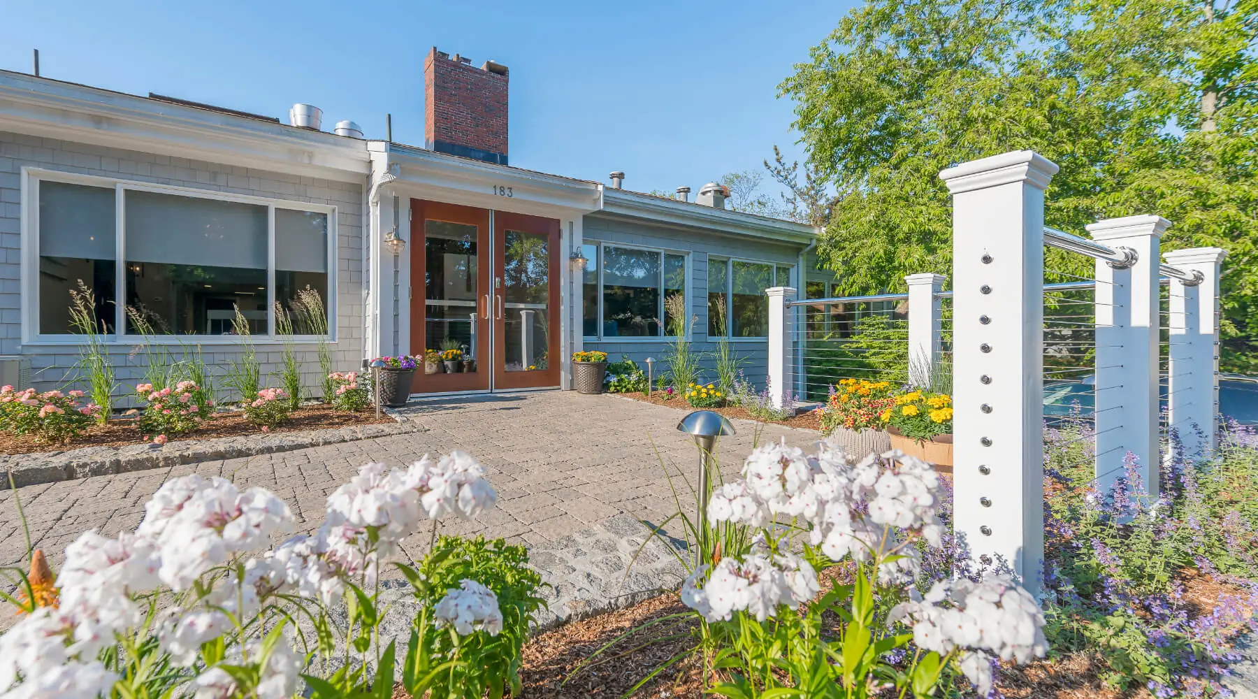
Our Headquarters Hotel is the Rockport Inn & Suites, located at 183 Main St. (MA Route 127), Rockport MA 01966.
TAKE ACTION NOW! Please book your hotel reservations while rooms are still available. They will only have vacancies for a very short period of time due to the large gathering for the nation's 250th Anniversary.
To book your room(s), guests may call the Rockport Inn & Suites directly at (978) 546-3300 and mention that you are with the "Cody’s Family Reunion" to receive our special group rate. As an alternative, we strongly advise to shop around for competitive rates through third-party sites such as Booking.com and Expedia.com to ensure you get the best deal.
If you want to stay somewhere else, no problem, this is your vacation and your comfort and happiness is our top priority! Here is a selection of links to recommended hotel accommodations in Rockport if our Headquarters Hotel doesn’t work for you:
| Register Now! Registration closes on May 15th! |
We recommend using the "Add to Cart" button to register for each type of person in your party; Adult, Child or Senior. Then you can adjust quantities using PayPal.com’s Shopping Cart page. |
|
| Review Your Registrations! Cancel by June 1st to avoid a 10% penalty. |
Use the "View Cart" button to adjust quantities to suit your needs. If the Shopping Cart’s "Continue Shopping" link doesn’t return you to this page, go to the top of your screen and close the latest tab. |
|
Monday, June 15 7- 10pm |
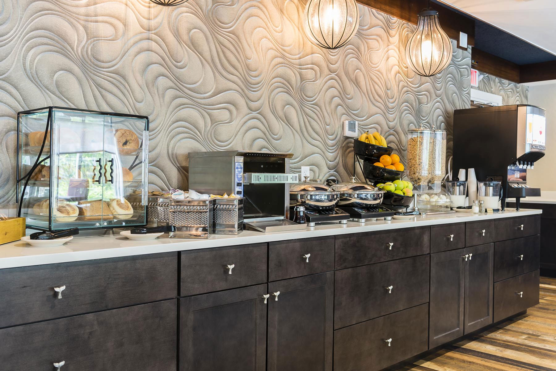
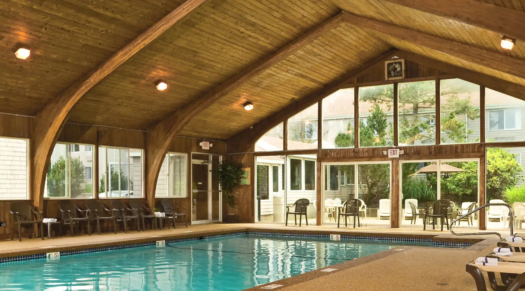
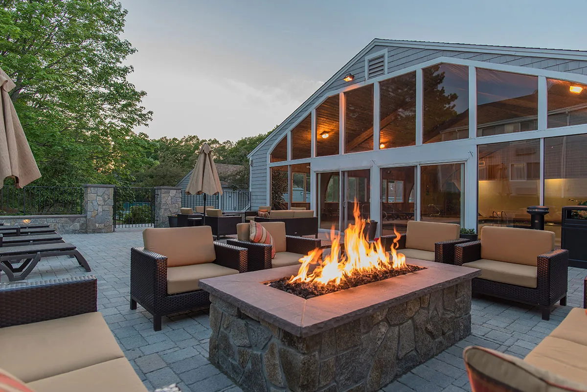
Welcome Registration at Rockport's Rockport Inn & Suites Lobby 183 Main St. (MA-127), Rockport The Rockport Inn & Suites is located 40 miles north of Logan International airport (LOG). The Rockport Inn & Suites is located 75 miles southwest of Manchester Regional airport (MHT). The Rockport Inn & Suites is located 104 miles north of T.F. Green airport (PVD). Take advantage of their amenities, including free hot breakfast buffet, complimentary WiFi and free outdoor parking. Also, you'll find an indoor pool, fitness center and a firepit areal! Registration Fees go towards miscellaneous Reunion costs. Check in and pick up your Gift Bag and meet and greet your Cuzzins! Late arrivals, contact Dwight Cody at 617-908-6258 to get your Gift Bag. For attendees without their own transportation, or who have room for a rider, please tell the Registrar of your need or capability during check-in at our Welcome Registration. |
  |
|||||||||||||||||
|
Tuesday, June 16 6:30- 9:30am Click for a map of today’s activities! |
Breakfast On Your Own Free breakfast for Rockport Inn & Suites' guests. Rockport has none of the popular fast food restaurants we're all so used to, they are located in the surrounding towns like Gloucester. If you're looking for a local alternative, try the Lattof Farmhouse Kitchen at 205 Main St., Delisi's Red Skiff at 15 Mount Pleasant St., or the Hula Moon Cafe at 27 Mount Pleasant St. |
 |
|||||||||||||||||
| 9:30- 10:00am |
Motorcade to the John Wise House 85 John Wise Ave. (US-1A/MA-133), at John Wise Lane, Essex We depart from the Rockport Inn & Suites and drive about 11 miles. Exiting the parking lot, turn right onto Main St., drive past the Rockport Visitor Center (on the left) and Sheehan Terrace (on the right) and continue on Eastern Ave./MA-127. After Harrison Ave. (on the left) keep right and merge onto MA-128 South. After Starbucks and Chipotle Mexican Grille (on left), at the traffic circle take the 2nd exit to stay on MA-128 South, at the next traffic circle take the 2nd exit to stay on MA-128, over the bridge, take Exit 53 for MA-133 West toward Essex. Turn right onto MA-133 West/Essex Ave., continue past The Mill sandwich shop (on left), over the bridge and past J.T. Farnham's clam shack (on right), past Grove St. (on left), past Perim Lang Antiques (on the right) to the intersection with Southern Ave., and keep right to continue on MA-133/Main St. Drive past Woodman's (on the left) and over the bridge, to continue on MA-133 past David Neligan Antiques (on the right), past Spring St. (on the right), past Western Ave. (on the left) and the Essex Fire Station (on the right), past the White Barn home goods store (on the right). Take the right off MA-133 onto John Wise Lane and park. Our destination is the dark gray house across MA-133 from Alprilla Farm (big red barn on the left), look for the John Wise Waymarker (on the right). If you get to the Essex Golf Club or the Essex Exchange antique store, you've gone too far. Please park safely, off the road. There is a breakdown lane on the highway and a vacant lot just before the red garage on John Wise Lane. |
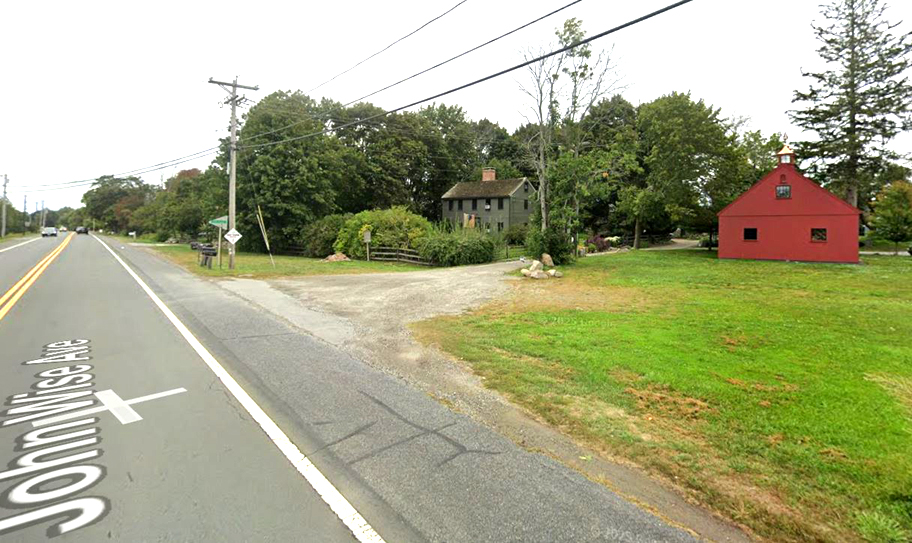 Click for a map to the John Wise House! 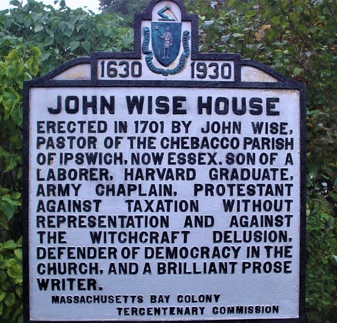 Look for the John Wise House Waymarker on the right at John Wise Lane! |
|||||||||||||||||
| 10:15- 10:45am |
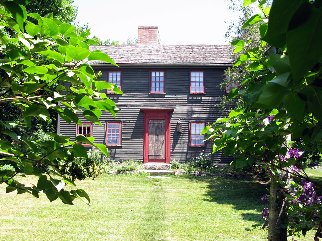
Visit the John Wise House 85 John Wise Ave. (US-1A/MA-133), at John Wise Lane, Essex In 1683, Reverend John Wise became the 1st minister of Chebacco Parish and inspired his parishners to rebel against British colonial mis-rule with the famous quote; "Taxation without respresentation is tyranny!" Please park safely, off the road, if you want you can drop off your riders and park at the Essex Exchange and walk back about 200 yards. Today, the house is a private residence, but we'll take a family portrait! |
 |
|||||||||||||||||
| 10:45- 11am |
Motorcade to the Old Burial Ground 28 Main St. (US-1A/MA-133), Essex Park right on Main St. (MA-133) or in the Municipal Lot. To park at the Municipal Lot, take the right just before The James restaurant onto Martin St. (MA-22), past the Brookline Bank and the Police Station on the left, take the first left onto Shepard Drive and look for the parking lot on the left. The Old Burial Ground was the scene of bodysnatching in the early 1800s! As local historian, Rob Fitzgibbon writes, "...(Dr. Sewall's grave robbing) is more than a creepy story of desecration during our nation's youth. The tale of the Body Snatcher of Chebacco Parish also touches on class, ambition, slavery, politics, and second chances in life." |
Click for a map to the Old Burying Ground and Municipal Parking Lot!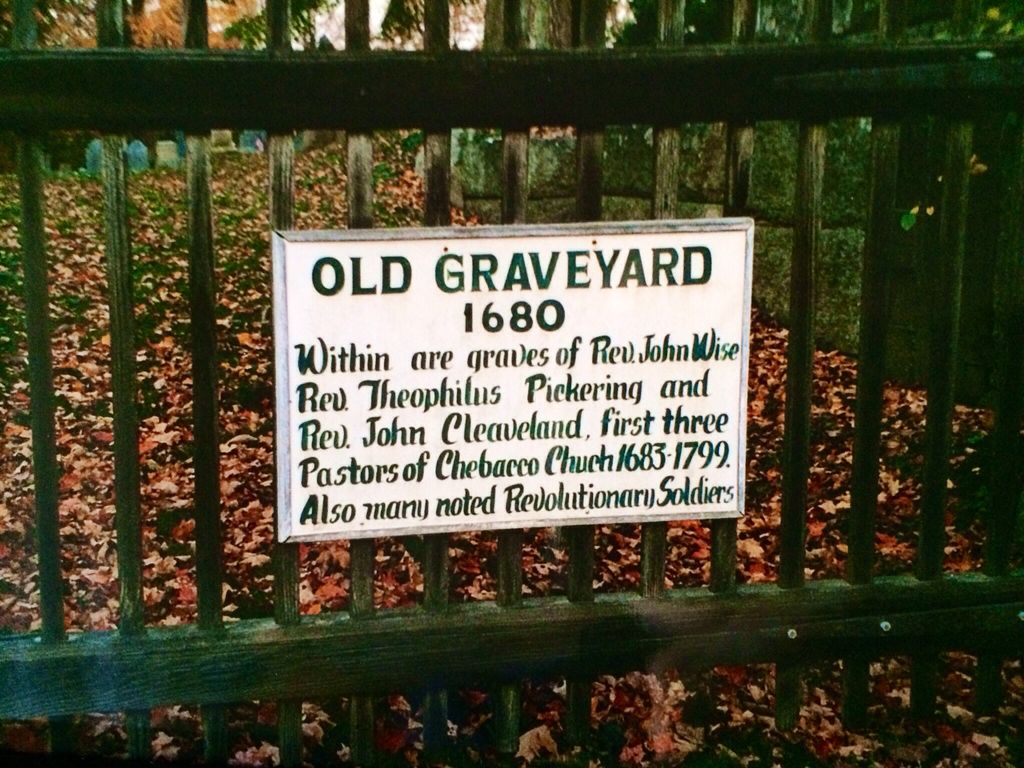 |
|||||||||||||||||
| 11- 11:30am |
Visit the Old Burial Ground 28 Main St. (US-1A/MA-133), Essex We’ll browse around the area, see the stone wall laid by our Joseph 3’s in-laws and visit Reverend John Wise's grave. We're not sure where Joseph's in-laws, Abraham and Sarah Martin are buried, but we'll see some of their contempraries' gravestones. Our Philip and Martha's son Joseph lived in a house abutting the graveyard and sold it to William Bennitt in 1723, when Joseph moved his family to Hopkinton. |
Click for a history of the Old Burying Ground!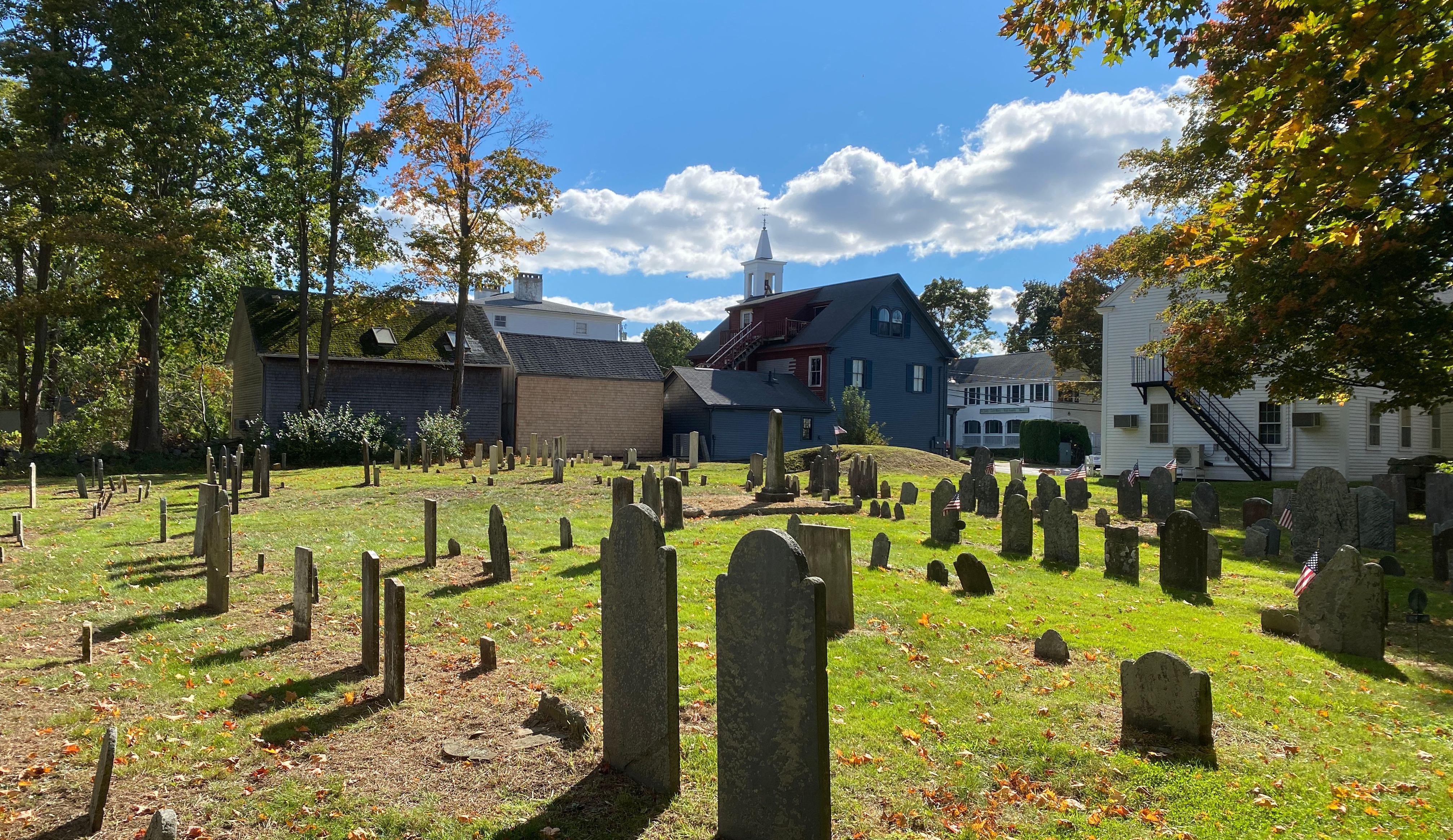 |
|||||||||||||||||
| 11:30- 11:45am |
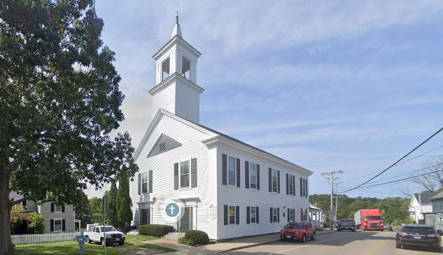
Walk to the 1st Congregational Church 39 Main St. (US-1A/MA-133), Essex We can walk to this institutional descendant of the original 2nd Parish by crossing back over Main St. to Essex's 1st Congregational Church. The original meetinghouse was located on land donated by the Cogswell family. It was the site of their first log cabin homestead in Chebacco, located on the path to Ipswich, near the yet-to-be-built John Wise House. Fearing the loss of tithes, the Elders in Ipswich had forbidden the men of Chebacco to build their own Meetinghouse, so 3 Chebacco women, Abigail (Proctor) Varney, Hannah (Dane) Goodhue and Sarah Martin, our Joseph 3's future mother-in-law, organized men from surrounding towns to come and build the first Chebacco Meetinghouse from timbers left over from the Cogswell's first homestead. It was a happy occasion, with lots of food, beer and rum! For this wanton act, they were arrested by a Constable, indicted by the Court in Ipswich and bound over to the Court in Salem. They apologized, repented and were forgiven by the Salem Court, which then decreed that the Chebacco Meetinghouse was good enough to stand and that Ipswich and Chebacco should make peace. |
Click for a map to the 1st Congregational Church!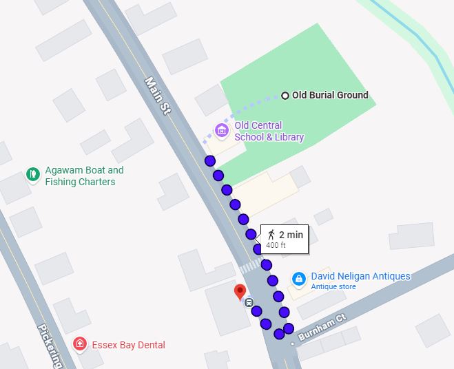 Click for the full story of the founding of Chebacco Parish, the 2nd parish in Ipswich! |
|||||||||||||||||
| 11:45am- 12:15pm |
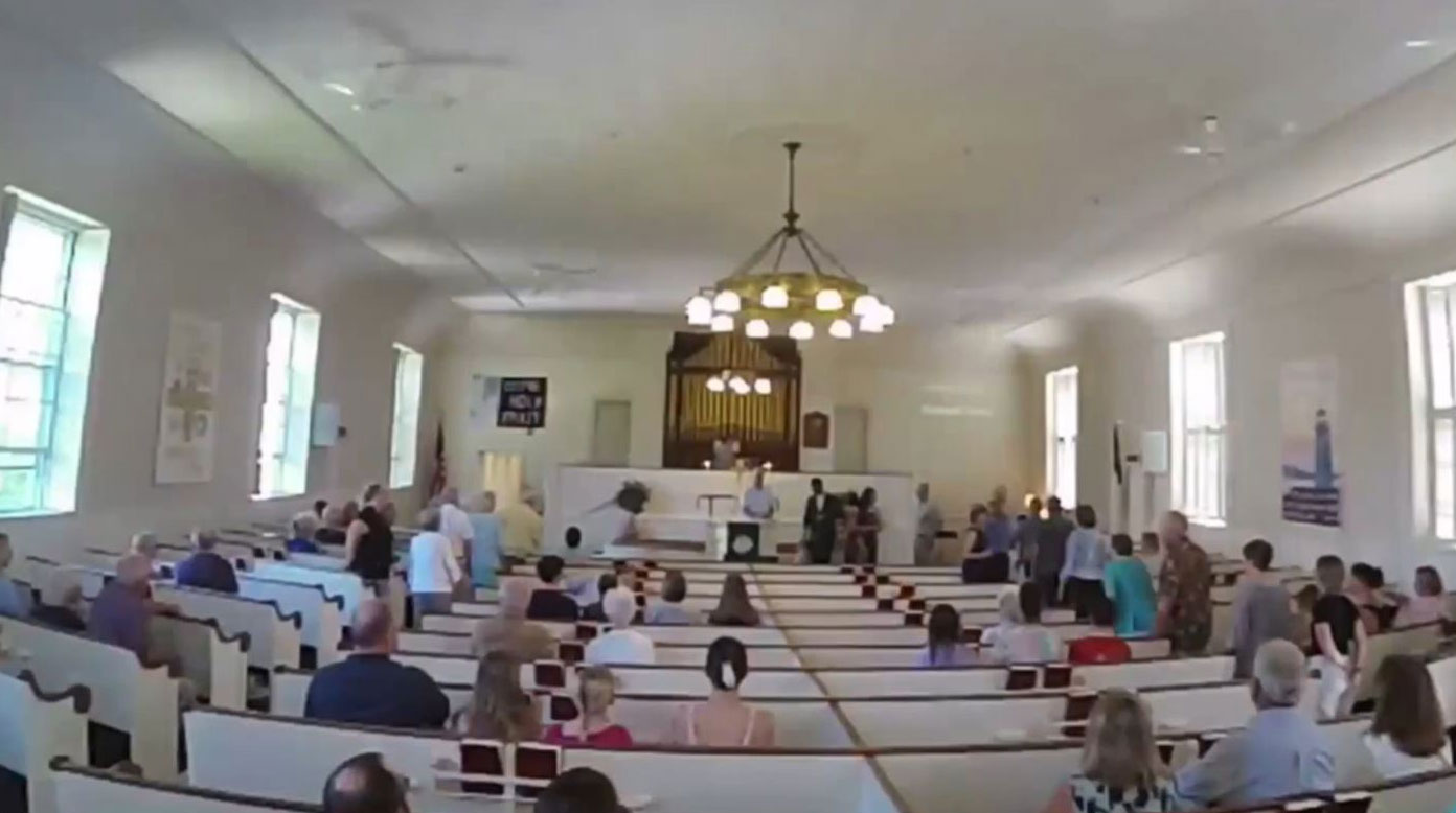
Visit the 1st Congregational Church 39 Main St. (US-1A/MA-133), Essex Chebacco Parish was established in 1679, after the residents of the southeastern part of Ipswich, known as Chebacco, began building their own meetinghouse and establishing a 2nd Parish in Ipswich. The 9-mile trip to worship in Ipswich was long, and even dangerous, particularly in winter, and exhausting for pallbearers, when the body was carried on the shoulders of men. But, to avoid losing revenue, the General Court of Ipswich restrained the men of Chebacco from continuing construction, some women of Chebacco, the Madams Varney, Goodhue, and Martin, organized men from Gloucester and Manchester (not subject to the Court's restraint) to build the first meetinghouse. It was finished in 1683, with logs donated by the Cogswells, hewed by them for their first home. The building was the meetinghouse for the religious gathering called Chebacco Church, and for the secular governing body of Chebacco Parish, including their own Militia. The Reverend John Wise was installed as its first pastor. In colonial New England the local church and government were closely associated. Both worship and government were conducted at the meetinghouse from the time of separation from Ipswich in 1679, through its incorporation in 1819, until a town hall was opened in 1894. |
  |
|||||||||||||||||
| 12:15- 12:30pm |
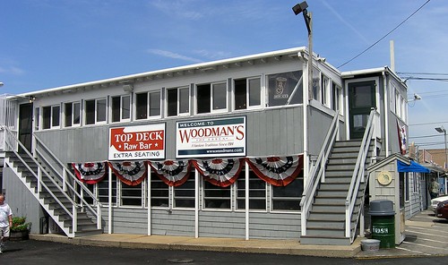
Motorcade to Woodman’s, the 'Home of the Fried Clam!' 119 Main St. (US-1A/MA-133), Essex Woodman's is right across the Essex River bridge from the 1st Congregational Church, but we recommend you drive to their parking lot. We’ll feast on the best seafood you can order in Essex County! As we approach Woodman's, on the left, we overlook the scenic estuary of the Essex River, where our Philip owned his parcel of salt marsh ground. As natives of Jersey, our Philip and Martha would have been familiar with seafood from childhood. |
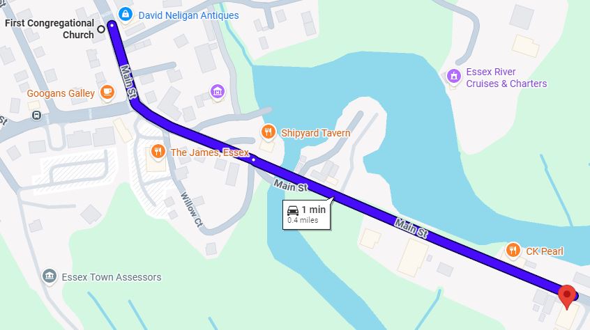 Click for a map to Woodman's! |
|||||||||||||||||
| 12:30- 1:30pm Pay As You Go! |
Family Lunch at Woodman’s, the 'Home of the Fried Clam!' 119 Main St. (US-1A/MA-133), Essex A family tradition since 1914, Woodman's is celebrating 112 years in business! Vogue magazine proclaims that "Woodman's of Essex is a culinary destination in and of itself." Lawrence 'Chubby' and Bessie Woodman opened their roadside clam shack on the causeway in Essex, MA. At that time, TV hadn't been invented, the average yearly salary was $750, and a gallon of milk cost 32 cents. WWI was just beginning, Babe Ruth was a rookie for the Red Sox, the fried clam hadn't been created, and it took all day on a beach to cook a New England clambake! In 1916 Chubby invented the Fried Clam and presented his new creation, clams coated with corn flour and deep fried in a kettle of lard, during the 4th of July parade in Essex. |
 Click for their menu! You can choose beween the whole Fried Clam, or Clam Strips, which is just the chewy foot of the clam, as popularized by the Howard Johnson's chain of restaurants. |
|||||||||||||||||
| 1:30- 1:45pm |
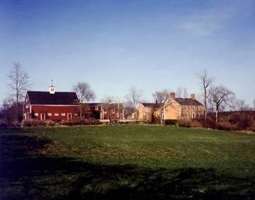
Motorcade to Cogswell's Grant 60 Spring St., Essex We'll drive back across the bridge, past the Old Burying Ground and take the first right onto Spring St. and drive up the hill to park near the house or barn. It's about a mile from the restaurant. We'll browse around the property and see the home of the Cogswell family, early settlers and prominent in the establishment of Chebacco Parish. Cogswell's Grant was the summer home of renowned collectors Bertram K. and Nina Fletcher Little, who purchased this 165-acre property overlooking the Essex River in 1937 and carefully restored the 1728 farmhouse as the perfect setting for their collection. The rooms overflow with folk art portraits, painted furniture, redware, hooked rugs, weathervanes, and duck decoys. |
Click for a map to Cogswell's Grant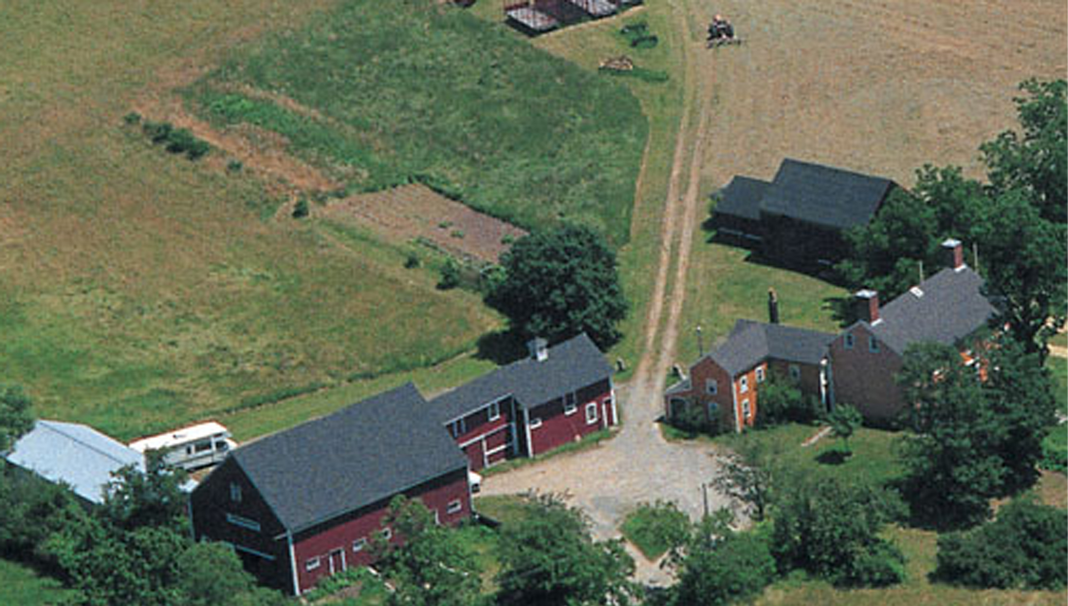 Unfortunately, the Folk Art Museum is only open on weekends. |
|||||||||||||||||
| 1:45- 2:15pm |
Visit Cogswell’s Grant 60 Spring St., Essex On May 23, 1635, John Cogswell and his family sailed from Bristol, England on the Angel Gabriel. This is the famous ship that was caught in the monster hurricane and was wrecked off the coast of Pemaquid, Maine on August 15, 1635. After the wreck, John and his family took to Ipswich whatever they could salvage from the water. Once there, the settlement gladly welcomed the family, as seen by the large grants of land made to him and over the years, the Cogswells prospered! |
 |
|||||||||||||||||
| 2:15- 2:30pm |
Motorcade to the Town Landing 66 Main St. (US-1A/MA-133), Essex We'll drive back down Spring St. and take the left at Main St. (MA-133) toward the bridge. We recommend parking along Main St., between the 1st Universalist Church on the right and the Shipyard Tavern on the left. Then look for the Essex Shipbuilding Museum's sign on Main St., just before the Shipyard Tavern. Walk past the Essex Shipbuilding Museum Giftshop, down the road to the river. To park at the Municipal Lot, take the right just before The James restaurant onto Martin St. (MA-22), past the Brookline Bank and the Police Station on the left, take the first left onto Shepard Drive and look for the parking lot on the left. Walk back up Martin St. to Main St., cross Main St. and turn right and walk toward the bridge. You could drop your riders off at the Landing first and then park the car. There's a $100 fine for parking in the Town Landing area without a sticker. Unfortunately, the adjacent Essex Shipbuilding Museum is closed on Tuesdays, but we'll be able to see what they're doing. |
 Click for a map showing the Municipal Lot, the 1st Universalist Church, the Shipyard Tavern and the Essex Shipbuilding Museum Giftshop!
 |
|||||||||||||||||
| 2:30- 3pm |
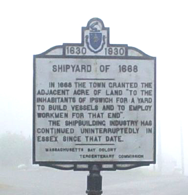
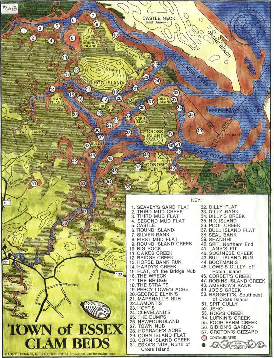
Visit the Town Landing 66 Main St. (US-1A/MA-133), Essex In 1668 the town granted the adjacent acre of land "To the inhabitants of Ipswich for a yard to build vessels and to employ workmen for that end." The shipbuilding industry has continued uninterruptedly in Essex since that date. Here, we'll soak up the atmosphere and reminisce about the place where we believe that our Philip and Martha's son Joseph first met his future wife, Mary, daughter of Abraham and Sarah Martin. Joseph and Mary's descendants account for about half of our present-day Cody family! Since our Philip owned part of the salt marsh across the river from the landing, he could harvest its hay as winter fodder for his animals. Naturally, his sons John, Joseph and perhaps little Isaac would accompany him on the 6-mile daytrip, riding on the cart. Since the salt marsh ground is too soft for a cart, so likely, they rafted the hay across the river, loaded it onto a cart at the town landing and hauled it back to Beverly. The Town of Essex Clam Beds Map provided the clue to finding Philip's salt marsh ground. |
 |
|||||||||||||||||
| 3- 4pm |
Motorcade back to the Rockport Inn & Suites It's rush hour, so take your time and if you're on a budget, pick up some take-out along the way! It’s been a big day, so why not gather at our Headquarters Hotel and chew the fat around the pool before supper? |
 |
|||||||||||||||||
| 6- 8pm |
Supper on Your Own Choose from one of the local restaurants and tour the Bearskin Neck artist’s colony after supper. Fresco's Seaside at 18 Beach St., Rockport House of Pizza & Roast Beef, Feather & Wedge at 5 Main St., My Place By the Sea at 68 Bearskin Neck and Fleur Cuisine Harborside at 1 T Wharf. |
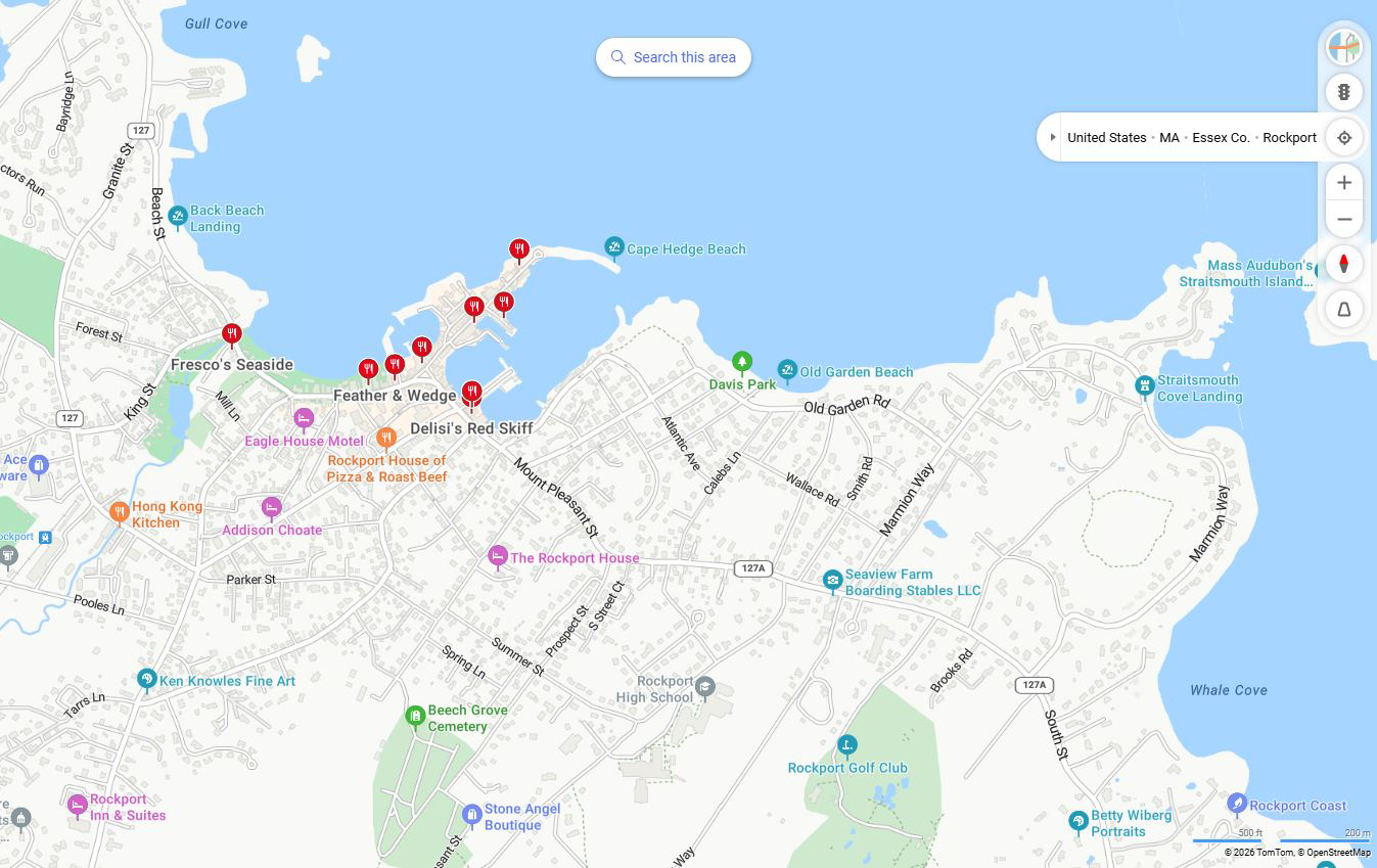 Click for a map to restaurants in Rockport! |
|||||||||||||||||
| 8- 10pm |
Relax & enjoy the Rockport Inn & Suites’ Amenities Pool, Spa, Gym, Arcade, Lounge, Gift Shop & Newstand with Free Coffee, Tea, and Internet. This is a good time to get to know each other better, introduce ourselves and ask any genealogical or historical questions you might have about our Cody Family! |
 |
|||||||||||||||||
|
Wednesday, June 17 6:30- 9:30am Click for a map of today’s activities! |
Breakfast on Your Own Free breakfast for Rockport Inn & Suites' guests. Rockport has none of the popular fast food restaurants we're all so used to, they are located in the surrounding towns, like Gloucester. If you're looking for a local alternative, try the Lattof Farmhouse Kitchen at 205 Main St., Delisi's Red Skiff at 15 Mount Pleasant St., or the Hula Moon Cafe at 27 Mount Pleasant St. |
|
|||||||||||||||||
| 9:30- 10:00am |
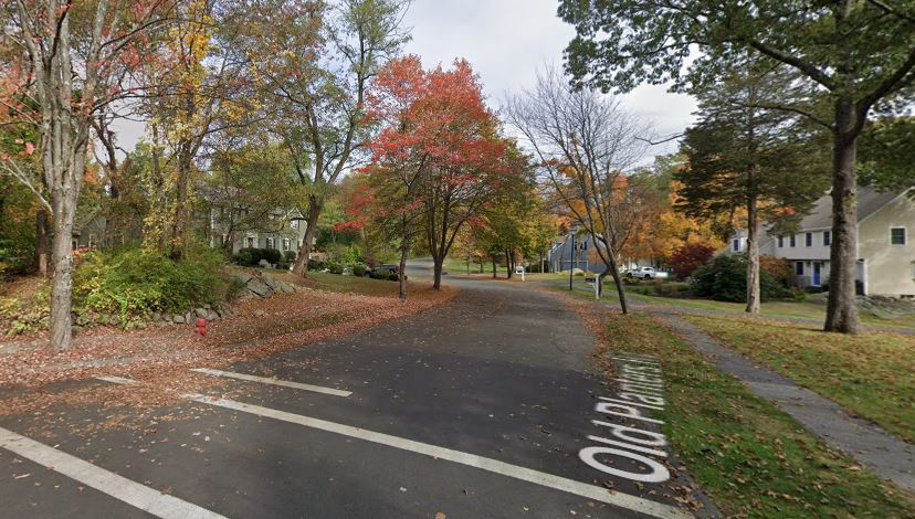
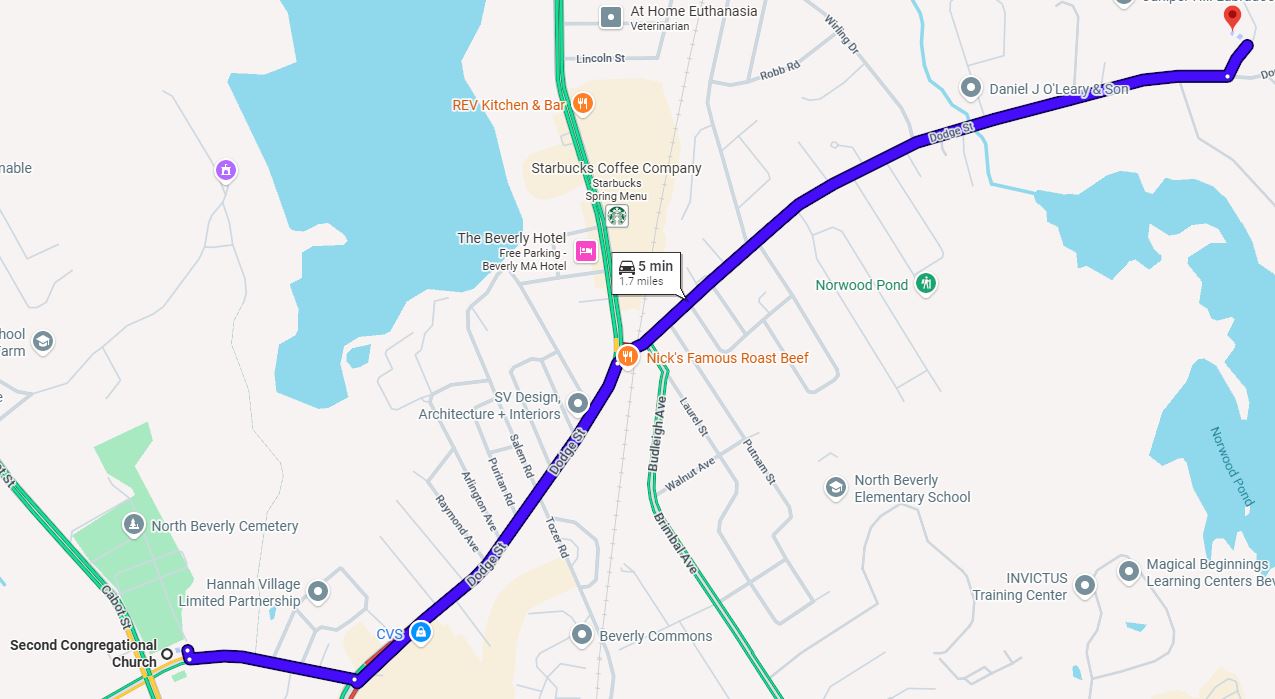
Motorcade to the site of our Philip and Martha’s Beverly Homestead Grover St., between Thaxton Rd. and Old Planter’s Rd., Beverly We depart from the Rockport Inn & Suites and drive about 16 miles. Exiting the parking lot, turn right onto Main St., drive past the Rockport Visitor Center (on the left) and Sheehan Terrace (on the right) and continue on Eastern Ave./MA-127. After Harrison Ave. (on the left) keep right and merge onto MA-128 South. After Starbucks and Chipotle Mexican Grille (on left), at the traffic circle take the 2nd exit to stay on MA-128 South, at the next traffic circle take the 2nd exit to stay on MA-128, over the bridge, take Exit 48 for Grapevine Rd./Beverly Farms toward Wenham (turn right at the end of the exit ramp). Continue on Grapevine Rd. past Gordon College (on left) and AJ Gordon Memorial Chapel (on right) and Gordon College's sign, stay on Grapevine past Rubbly Rd./MA-22N, continue on Grapevine/MA-22S past Essex St./MA-22S to its end at Larch Row, Turn left onto Larch Row, proceed to the 4-way intersection and turn left onto Dodge's Row, after Spring Hill Farm Rd. (buildings on a hill to the left) take the first left onto Grover St., then take the first left onto Thaxton Rd., right onto Cummock St., down to Old Planter's Rd. and pull over in a safe spot. |
 Click for a map to our Philip and Martha's Beverly Homestead! 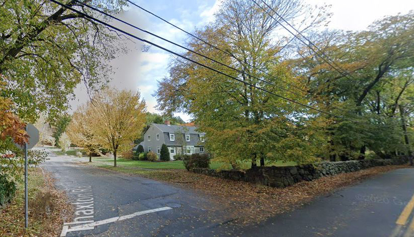 |
|||||||||||||||||
| 10:00- 10:30am |
Visit the site of our Philip and Martha’s Beverly Homestead Grover St., between Thaxton Rd. and Old Planter's Rd., Beverly We'll visit the site of our family progenitor's 6-acre parcel, which they bought from Thomas Edwards, after they were accepted into the church in Beverly. Here, they kept sheep, made cider from the fruit trees and farmed next door to the Peter Wooden family and later, the Dike family. The deeds describes our Philip first as a mariner, and later as a weaver. But as natives of Jersey, from childhood, our Philip and Martha would have been skilled at knitting and likely spent many evenings knitting socks around the fire. The Cody Family Association first visited this site during their 1941 Reunion, guided by Luther M. Cody. The housing development wasn't there at that time, so the area was vacant, except for a cellerhole. Luther was led to this place by Sidney Perley, who located it using the Beverly Homestead Deed. It was an emotional moment for some, this being the climax of a long investigation into our family's origins! We last visited this site during our 1998 ICFA Reunion. We'll get out and walk around, look for the likely spot of the house, with water nearby, and take a family portrait. |
Click for Google Streetview at Thaxton Rd.! |
|||||||||||||||||
| 10:30- 10:45am |
Motorcade to Dodge's Row Burying Ground 282-286 Dodge St., Beverly From Thaxton Rd., turn right onto Grover St., take a left onto Dodge St., look for the sign for Beaver Pond Rd. on the left, continue round the bend, past a field and a house (286 Dodge St.) on the right, slow down and look for the mailbox (284 Dodge St.) on the right, turn right at the corner before for the little white cottage (282 Dodge St.) on the right. Take the access road, between 286 Dodge St. and 282 Dodge St. past the two homes (282 and 286) and stay right as you drive along it. You will pass two more homes with driveways on the left. Stay right, the access road ends at the graveyard. Park on the right shoulder of the access road. |
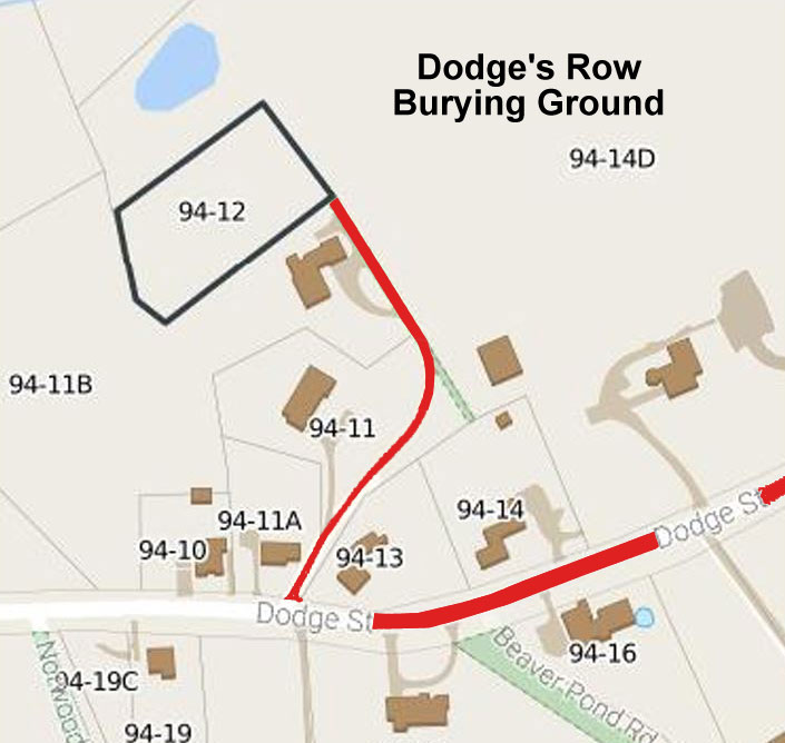 Click for a map to Dodges Row Burying Ground from Thaxton Rd.! |
|||||||||||||||||
| 10:45- 11:15am |
Tour Dodge's Row Burying Ground 282-286 Dodge St., Beverly Richard Dodge and his family arrived in Salem in 1638 and lived with his brother William, who had come to Salem in 1629. William prospered and gave Richard 40 acres of his land in 1641. Richard built a home and farmed. Richard held education in high esteem, for in 1653, he was the biggest contributor to Harvard College in his town. He also gave a piece of his land for this burying ground. The Dodges helped establish the 1st Parish Church and were good friends of Reverend John Hale. Here are some Dodge family graves of people from our Philip and Martha's era;
It'll be fun to see how many of them we can find! |
 Click for a map of Dodge's Row Burying Ground! |
|||||||||||||||||
| 11:15- 11:30am |
Motorcade to the 2nd Congregational Church 35 Conant St., Beverly As we exit the Dodge's Row Burying Ground Access Road, take the right onto Dodge St., and continue past Norwood Pond Rd. (on the left), Longham Rd. and Morningside Dr. (both on the right), Whitaker Way (on the left), Wirling Dr. (on the right), Elnew Ave., Red Rock Ln., Berrywood Ln., Oakhurst Rd., Northwood Rd., Roy Ave., Putnam St., and Laurel St. (all on the left), over the railroad tracks to Enon St. where you'll see a sign for US-1A Take the left onto 1A, past Nick's Famous Roast Beef and Hogan Tire (both on the left), past Pershing Ave. (on the right), Wilkins St. (on the left), Devon Ave., Somerset Ave., and Salem Rd. (all on the right), Puritan Rd. (on the left), Arlington Ave., Raymond Ave. and King Ter. (all on the right), Longwood Ave. (on the left), Frankwood Ave. (on the right), stay to the right as we approach Conant St., the road divides and there's a traffic light. Straight through the traffic light, past Shaw's (on the left), and take the right onto Conant St., past the Dollar Tree (on the left), Chipman Rd. (on the left), look for the 2nd Congo's white steeple on your right, and park in the lot. |
 Click for a map to the 2nd Congo! 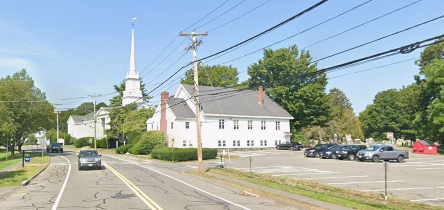 |
|||||||||||||||||
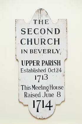
| 11:30am- 12pm |
See the 2nd Congregational Church 35 Conant St., Beverly The church has been sold and all the property has been auctioned off, but we can take a family portrait! The 2nd Parish is where our Philip and Martha worshipped after they were invited to join by their neighbors. The establishment of the Upper Parish was similar to the story of the Chebacco Parish, where the distance to the meetinghouse proved to be the catalyst for action. It was likely here that Philip and Martha learned of the prospects of pioneering in Hopkinton and decided to take up Harvard's lease for a 100-acre farm. Their married sons, John and Joseph followed with their families, so that by 1730, our family all lived in Hopkinton. It was Martha's Letter of Dismissal from this church to the church in Hopkinton that provided the clue used by our James Lincoln Chapman to find the Church Records in Beverly which indicated that our Philip and Martha LeCody came from Beverly. It was in Beverly where our 'LeCody' family records were discovered, which eventually linked our family to Jersey. Robert Dodge (1686-1764) and wife, Lydia Woodbury (1691-1759) were buried in the 2nd church's old church-yard, where their gravestones still stand. You can see this graveyard on the rustic path between #9 and #27 Conant St. |
 |
|||||||||||||||||
| 12- 1pm Pay As You Go! |
A Quick Lunch On Your Own There's a McDonald's at 230 Elliot St. and another at 40 Colon St. and Flip the Bird at 470 Cabot St. For a quick submarine sandwich, try the Super Sub Shop at 324 Cabot St. or Tasty Subs at 496 Cabot St. The Anchor Pub & Grille, 20 Cabot St. has King Crab Legs, Steamers, Steak Tips, Sandwiches and Pizza with easy parking. The Mission Boathouse, 1 Water St. features Oysters, Mussels, Tuna, Shrimp, Swordfish, Short Ribs, Sandwiches, Pasta and Pizza with off-street parking. Toscana Bar Italiano, 90 Rantoul St. has Oysters, Mussels, Shrimp, Tuna, Swordfish, Sandwiches, Pasta and Pizza with easy parking. Burger King, Tuscan Hills Pizzeria, the Kitchen Table, Early Harvest Diner and Mikey's Famous Roast Beef & Pizza are located a short distance from the Balch House, so look at the map and see what you like! |
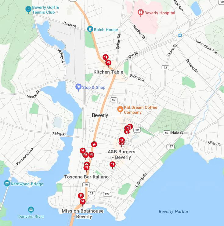 Click for a map to the Balch House! |
|||||||||||||||||
| 1- 1:15pm |
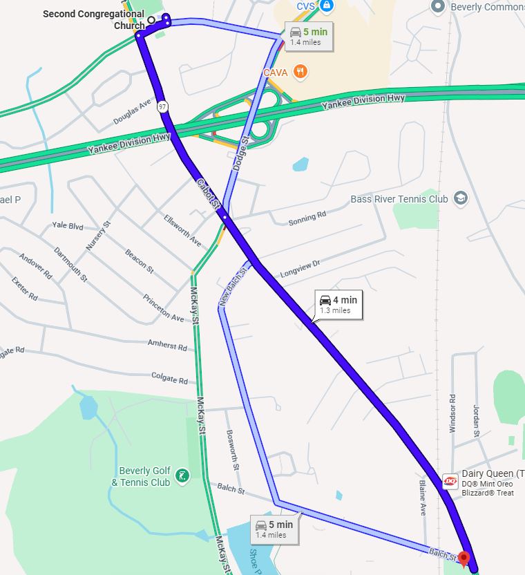
Motorcade to the Balch House 448 Cabot St., Beverly As we exit the 2nd Congo Church parking lot, we take a right onto Conant St., take the first left onto Cabot St. (MA-97), past the athletic fields on the left, past Douglas Ave. (on the right), under the highway, past Trafalgar Dr. (on the right), Tremont St. (on the right), to the big intersection with US-1A. Continue straight through the big intersection with US-1A, past Flair Cleaners (on the left) and American Petroleum (on the right), past New Balch St. (on the right), past Longview Dr. and Hill St. (both on the left), past Living Hope Church, Columbia Rd., Auburn Rd., Bradford Rd., Blaine Ave. (all on the right), continue over the railroad tracks, and take the right onto Balch St., then take the first left into the Balch Playground parking lot, behind the Balch House. The Balch House is across the street from a Cabot Fuels gas station. |
 |
|||||||||||||||||
| 1:15- 1:30pm |
Visit the Balch House 448 Cabot St., Beverly The John Balch House is one of the oldest wood-frame houses in the United States. It is now operated as one of the historic house museums of Historic Beverly. Built in 1679 by the "Old Planter," John Balch, who traded his land in Salem for this site in 1635 through the "1,000 Acre Grant". The house is composed of structures from three architectural periods. The 1680s northeast portion, likely built by Benjamin Balch, is a rare example of a 17th century one and one-half story dwelling. In 1721, this early structure was incorporated into a larger two-story addition to the south. The 17th century structure was raised to a full two stories and with the chimney added to the north end of the 18th century addition; the transformation to a typical five bay colonial was complete. In the late 18th or early 19th century a large addition was added on the west side. |
Click for Google's Streetview of the Balch House!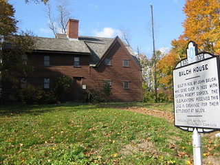 |
|||||||||||||||||
| 1:30- 1:45pm |
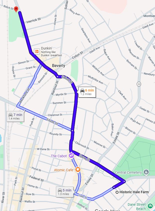
Motorcade to the Hale Farm 39 Hale St., Beverly As you exit the Balch Playground Parking Lot, take the right onto Balch St. to the light, take a right onto Cabot St., continue past Cabot Fuels (on the left), the baseball field (on the right), Kelly Ford (on the right), Cabot Plaza & Dunkin' donuts (on the left), to the light at Beckford St. (on the right), past Domino's Pizza (on the right), past the Kitchen Table & Bennett St. (both on the right), straight through the light at Subway (Colon St.), across the railroad tracks and up to the traffic light. Wait for the light and bear to the left at the intersection to stay on Cabot St. (take the left fork), continue past the Dollar Tree (on the left), past Pickett St. (on the left) and Lenox St. (on the right), past Columbus Ave. and Harrison Ave. (both on the left), past Chestnut St. and Elliot St. (both on the right), past One Stop Market & Liquors (on the left), to the United Methodist Church (fieldstone tower on the right) at the Dane St. traffic light. Take the left onto Dane St. (follow MA-62E) past the Speedway gas station (on the right), past the quaint yellow building with brown trim, the white Anchor Bay Church (both on the left), continue across Knowlton St., across Essex St., past Beverly Common (on the right), past Butman St, (on the left), to the stop sign at Hale St., and take the right onto Hale St., take the 1st left onto Bancroft Ave., park on the right side of the street and it's a short walk to the Hale House on Hale St. |
Click for a map to the Hale Farm!
 |
|||||||||||||||||
| 1:45- 2pm |
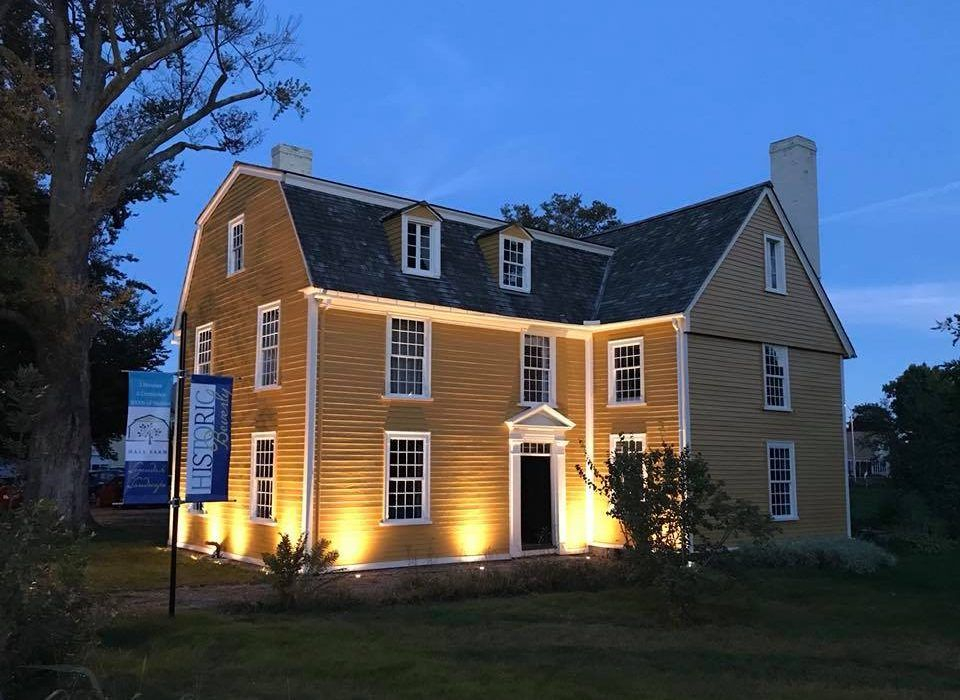
Visit the Hale Farm 39 Hale St., Beverly We'll visit the residence of Reverend John Hale, who welcomed our Philip and Martha to Beverly. John Hale served as the pastor at Beverly's First Parish Church until his death in 1700 and was buried in the Abbot St. cemetery. Reverend Hale played a role as 'expert witness' in the 1692 Salem witchcraft trials and later wrote a posthumously published book, "A Modest Inquiry into the Nature of Witchcraft," in an effort to explain what had happened. That book was written at Hale Farm. |
Click for a bio of Rev. John Hale!
 |
|||||||||||||||||
| 2- 2:15pm |
Motorcade to the 1st Parish Church 225 Cabot St., Beverly We'll get back in our cars and continue on Bancroft Ave., as it loops around the Hale Farm to Hale St., take the left onto Hale St. and continue past St. Peter's Church at Ocean St. (both on the left), past Atlantic Rd. (on the left), bear right at fork with the Fire Station (on the left) to continue on Hale St., up to the crosswalk and take the right onto Briscoe St. (behind the 1st Parish Church) and then a quick right into the Ellis Sq. Public Parking lot (on the right). Park, pay at the kiosk and walk to the front of the church. |
Click for a map to the 1st Parish Church!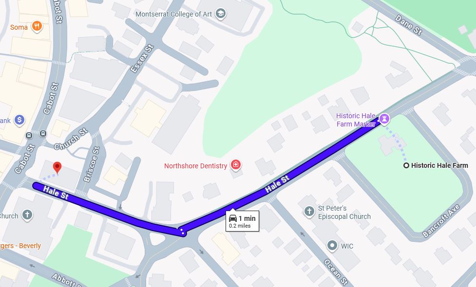 |
|||||||||||||||||
| 2:15- 2:45pm |
Visit the 1st Parish Church 225 Cabot St., Beverly We'll tour the place where our Philip and Martha first joined the congregation in Beverly. Church membership was a requirement for land-owning in Puritan times so this was a big step as they completed their term of indenture to their 'boss,' Philip English. As his employees, they would have lived in his "Great House" in Salem, ate his food, and worshipped along with him at the Puritan church in Salem. From John Hale's Puritan Church of 1667 to the present day, First Parish Church in Beverly is steeped in history, including the establishment of the first Sunday School in New England, which continues in its mission of religious education to this day. Here, you can learn about everything from the advent of what became known as the Salem Witch Trials to the former church bell, crafted by Revolutionary War patriot, Paul Revere. Today's church building was erected in 1772. |
Click for a sketch of the Original Beverly Church!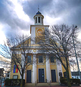 |
|||||||||||||||||
| 2:45- 3pm |
Motorcade to the Cabot House 117 Cabot St., Beverly Exit the church parking lot by taking a right onto Hale St. go past Brisco St. to the stop sign at Cabot St., turn left onto Cabot St., continue past Bow St. (on the right), past Thorndike St. and Washington St. (both on the left) and take a left onto Franklin Place, there's a parking lot on the left. Cabot House is the brick building across Franklin Place facing Cabot St. |
Click for a map to the Cabot House!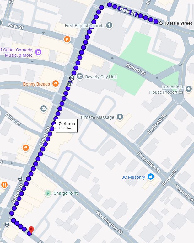 |
|||||||||||||||||
| 3- 3:15pm |
Visit the Cabot House 117 Cabot St., Beverly Here, at Historic Beverly, we'll view the 1st Parish Book where Rev. John Hale first recorded our Philip and Martha as members of his congregation, a vital step toward confirming the purchase of their Beverly Homestead. Later, at the insistence of their neighbors, they would join the 2nd Parish church. |
Click for more about the Cabot House!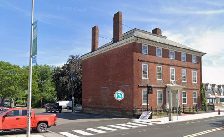 |
|||||||||||||||||
| 3:15- 3:45pm |
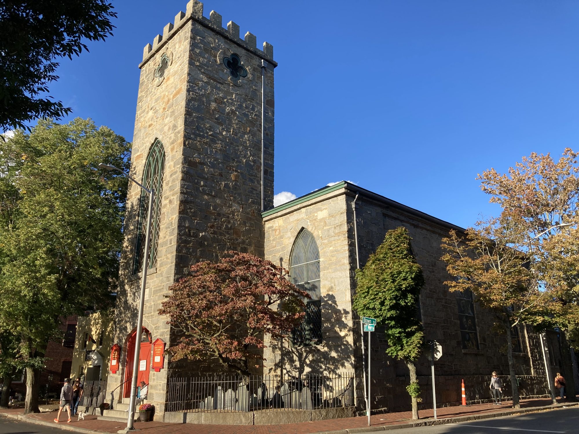
Motorcade to Salem's Public Parking 1 New Liberty St., Salem Exit the parking lot by taking a right onto Hale St., past Briscoe St. to the stop sign at Cabot St., turn left onto Cabot St., continue past Abbot St. (on the left) and Bow St. (on the right), past Thorndike St. (on the left) and Broadway (on the right), Washington St. (on the left), Railroad Ave. (on the right), Central St. (on the left), past Union St. (on the left), cross School St., up to the traffic light at Rantoul St. (on the right), past Water St. (on the left), to the Essex Bridge. Cross the Essex Bridge and keep right for Salem Ctr (MA107 to 114) on Sgt. James Ayube Mem. Dr., past the overpass, to the traffic light where the highway ends, straight through the light onto Bridge St., stay to the left and take the first left onto St. Peter St., past Federal St. (on the right), to St. Peter's Church at the Church St./Brown St. intersection. You can use the open-air Public Parking lot on Church St., or turn left onto Brown St. and take the first right onto New Liberty St. for the Witch City Mall Parking Lot. We'll meetup at St. Peter's Church, founded by Philip English in 1733. |
Click for a map to Salem's Public Parking!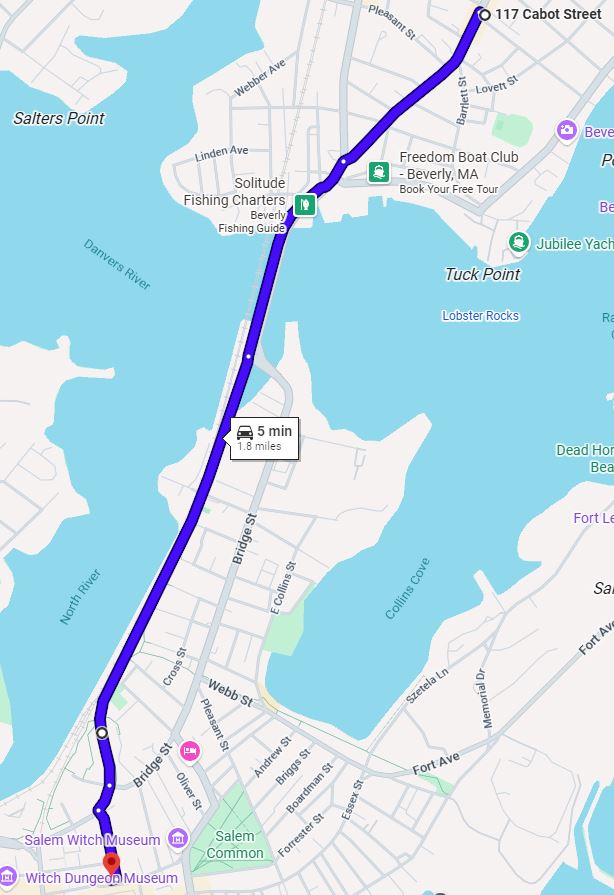 |
|||||||||||||||||
| 3:45- 4pm |
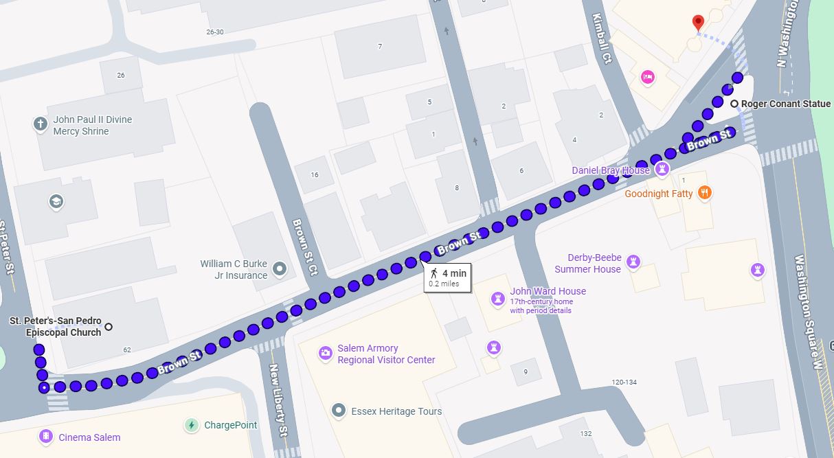
Walk to the Salem Witch Museum 19½ North Washington Square, Salem We'll meetup at St. Peter's Church and walk down Brown St., past New Liberty St. (on the right), past Brown St. Court, Howard St. and Kimball Court (all on the right) to the Roger Conant statue to find the Salem Witch Museum on the left. Roger Conant (15921679) was 'Governor' of the original fishing settlement at Naumkeag before the Puritans arrived and graciously submitted to Puritan rule. He was a popular and extraordinary man. One of the 'Old Planters' of Beverly, his daughter Mary married the 'Old Planter', John Balch, and later William Dodge. Along with Richard, John and William Dodge, Roger and his sons, Lot and Exercise, were founding members of Beverly's 1st Parish. While our Philip and Martha came to Beverly after Roger and Lot's deaths, they certainly knew Exercise Conant. |
Click for a map to Salem's Witch Museum!
 |
|||||||||||||||||
| 4- 4:45pm Pay As You Go! Adults: $19.00 Seniors (62+): $17.50 Children (Ages 6-14): $16.00 |
Visit the Salem Witch Museum 19½ North Washington Square, Salem We'll pass the statue of the pioneer, Roger Conant, on the way to the Salem Witch Museum! Along with Richard, John and William Dodge, Roger and his sons, Lot and Exercise, were founding members of Beverly's First Parish. While our Philip and Martha came to Beverly after Roger and Lot's deaths, they certainly knew his son, Exercise Conant. |
Click for Roger Conant's bio!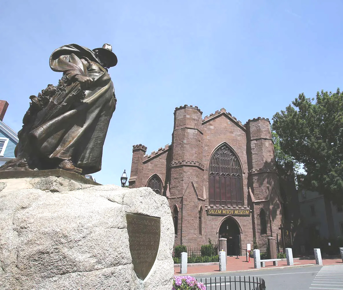 |
|||||||||||||||||
| 4:45- 5pm |
Walk to Saint Peter's Church 24 Saint Peter St., Salem We'll retrace our steps, past the Roger Conant Statue, onto Brown St., past Kimball Court, Howard St., Brown St. Court (all on the right) and New Liberty St. (on the left), to the corner of St. Peter St., across from Salem's Public Parking. The land for an Anglican Church was donated by Philip English in 1733. After all he had been through, with the Witchcraft Hysteria, the looting of his 'Great House' and the loss of his wife Mary, maybe he wanted to leave a lasting mark on Salem! |
Click for a map to Saint Peter's Church!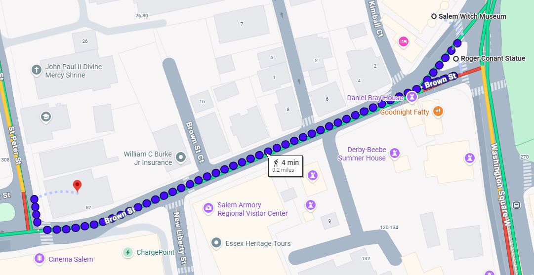 |
|||||||||||||||||
| 5- 5:30pm |
Visit Saint Peter's Church 24 Saint Peter St., Salem Philip English, born in 1651, came to Salem from the Channel Island of Jersey and parlayed his father-in-law's fishing business into an international trading company and frequently returned to Jersey to enlist employees. It's very likely that he was bankrolled by the DeCarteret family, since his birth record mentions a DeCarteret as a godparent. Although Philip English was a subject of the English Crown, he was not a Puritan and therefore suspect, which led to his and his wife's witchcraft indictment in 1692. Using his wealth and influence, he and his wife escaped to New York, and returned after the hysteria passed. In the meantime, his house had been looted, and after they returned, his wife died, but Philip rebuilt his business, and eventually died in 1736. It's very likely that our Philip and Martha, either together or separately, signed the indenture contract and came to Salem as his servants for the economic opportunity it offered. By the time Mr. English died, our Philip and Martha had fulfilled the contract and leased their 100-acre Hopkinton farm. |
 Click for how Philip English donated the land for this church and was buried in the church-yard! |
|||||||||||||||||
| 5:30- 5:45pm |
Motorcade to the site of Philip English's 'Great House' 11 Essex St., Salem We'll assemble our motorcade at the Church St. East Lot and proceed down Brown St. to Roger Conant's Statue, where we turn right onto Hawthorne Bvld., take the 1st left onto South Washington Square St., continue to its end and take the right onto East Washington Square St., take the 1st left onto Essex St. Continue on Essex St., past Daniels St., Bentley St., Hardy St., Turner St., Carlton St., Becket St. and Gerrish Place (all on the right) to the corner of English St., park at the corner or take the right onto English St. to park and view the site of Philip English's 'Great House'. |
Click for a map to the site of Philip English's 'Great House'!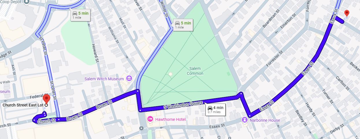 |
|||||||||||||||||
| 5:45- 6pm |
Visit the site of Philip English's 'Great House' 11 Essex St., Salem Philip English's 'Great House' was built in 1685, remained in the family till 1745, was taken down in 1833, and is now replaced by a private home, but we can still look down Essex St. to Collins Cove and say "We've been there." From the commemorative article printed in the Nantucket Inquirer in 1833, "It was a wooden house, framed of oak, and the interstices filled up with brick, as was usual in the early days of the settlement. It was built in the year 1685, and was consequently 148 years old. It was of that form called an L house with the internal angle fronting the South." How many times did our Philip and Martha look out those windows and imagine what they left behind in Jersey? |
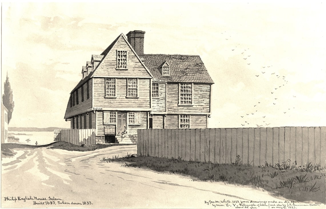 Click for a bigger picture of Philip English's 'Great House', looking down Essex St. to Collins Cove! |
|||||||||||||||||
| 6- 6:15pm |
Motorcade to the site of Mary English's Blue Anchor Tavern 60 Derby St., Salem We'll drive down English St., past Cousins St. and Allen St. (both on the left) to Derby St., turn left and park. We'll view the private residence at 60 Derby St., the site of Philip English's Blue Anchor Tavern and then walk a block up Derby to India St., the approximate site of Philip English's Wharf! As servants of Philip English, our Philip and Martha would be familiar with these places because it's likely that Martha worked as a barmaid at the tavern while Philip took ship to the fishing grounds from the wharf. In our Philip and Martha's day, Derby St. was Shore Rd., but now the original shoreline has been replaced by filled-in land, so the shoreline is further away. |
Click for a map to the site of Mary English's Blue Anchor Tavern!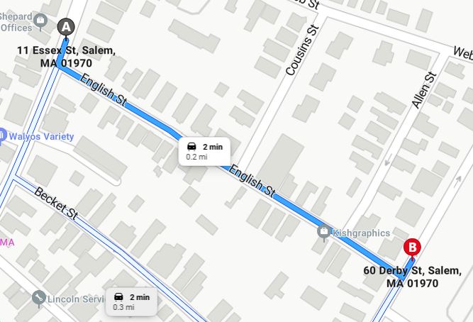 |
|||||||||||||||||
| 6:15- 6:30pm |
Visit the site of Mary English's Blue Anchor Tavern 60 Derby St., Salem The Blue Anchor Tavern was established in 1674 when maritime trader William Hollingworth was at sea, and his wife, Eleanor Hollingworth, was granted a license to operate an ordinary (tavern) in their mortgaged house on Salem Neck, at the corner of Derby and English Streets. Eleanor brewed her own beer in a dedicated brew house, demonstrating remarkable independence for a woman of her time. After William was declared lost at sea in 1677, Eleanor managed his estate, paid off debts, and fully owned the tavern by 1682. She was a strong and influential figure, even facing accusations of witchcraft in 1685, and left a substantial inheritance to her daughter Mary upon her death in 1689. Mary's parcel is shown on the map as the 'Estate of Mary English'. |
Click for the Salem Witch Museum's page about Mary's Blue Anchor Tavern!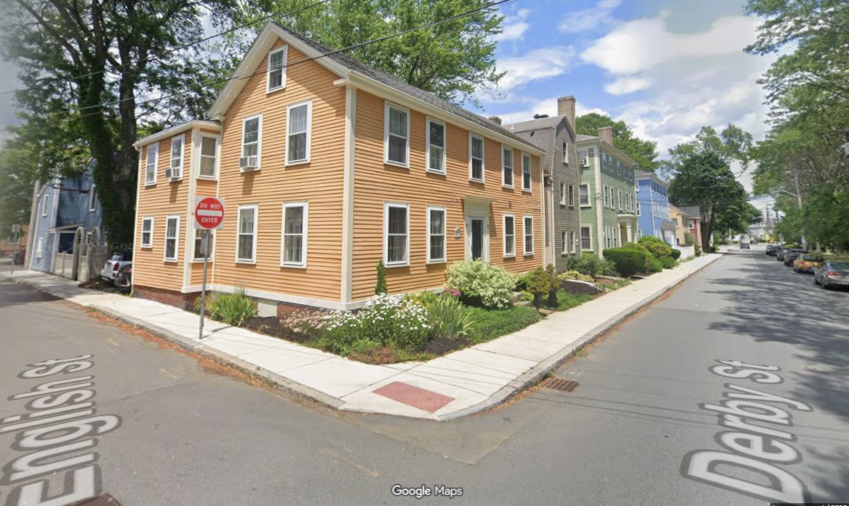 |
|||||||||||||||||
| 6:30- 6:45pm |
Visit the site of Philip English's Wharf India St., Salem From the site of the Blue Anchor Tavern, we'll walk a block to see the approximate site of Phlip English's Wharf, where our Philip and Martha first set foot in Salem. This is our 'Ellis Island', the place where our immigrant ancestors first arrived in the New World! The colorized map on the right is extracted from William W.K. Freeman's version of Sidney Perley's map, "Part of Salem in 1700" and shows the site of Philip English's 'Great House' (in red) at the head of English's Lane (English St.), which runs to his wife, Mary Hollingsworth English's land where she kept the Blue Anchor Tavern (in blue), across the shore road from Philip's wharf (in green) where he ran the ferry to Marblehead. The tavern was strategically located with a large storehouse and wharf in front, near the starting point of the Marblehead Ferry. This made it convenient for travelers arriving by coastwise boats and for those involved in the fishing industries at Winter Island. The tavern served as a hub for both locals and visitors, providing lodging, food, and drink, and facilitating commerce and travel along the Salem coastline. Its proximity to the ferry connected Salem to Marblehead, enhancing trade and communication in the region. The map also shows William Becket's shipyard, handily nearby, where ships were built, repaired, careened, outfitted and made seaworthy. |
Click for Sidney Perley's map of Salem in 1700! 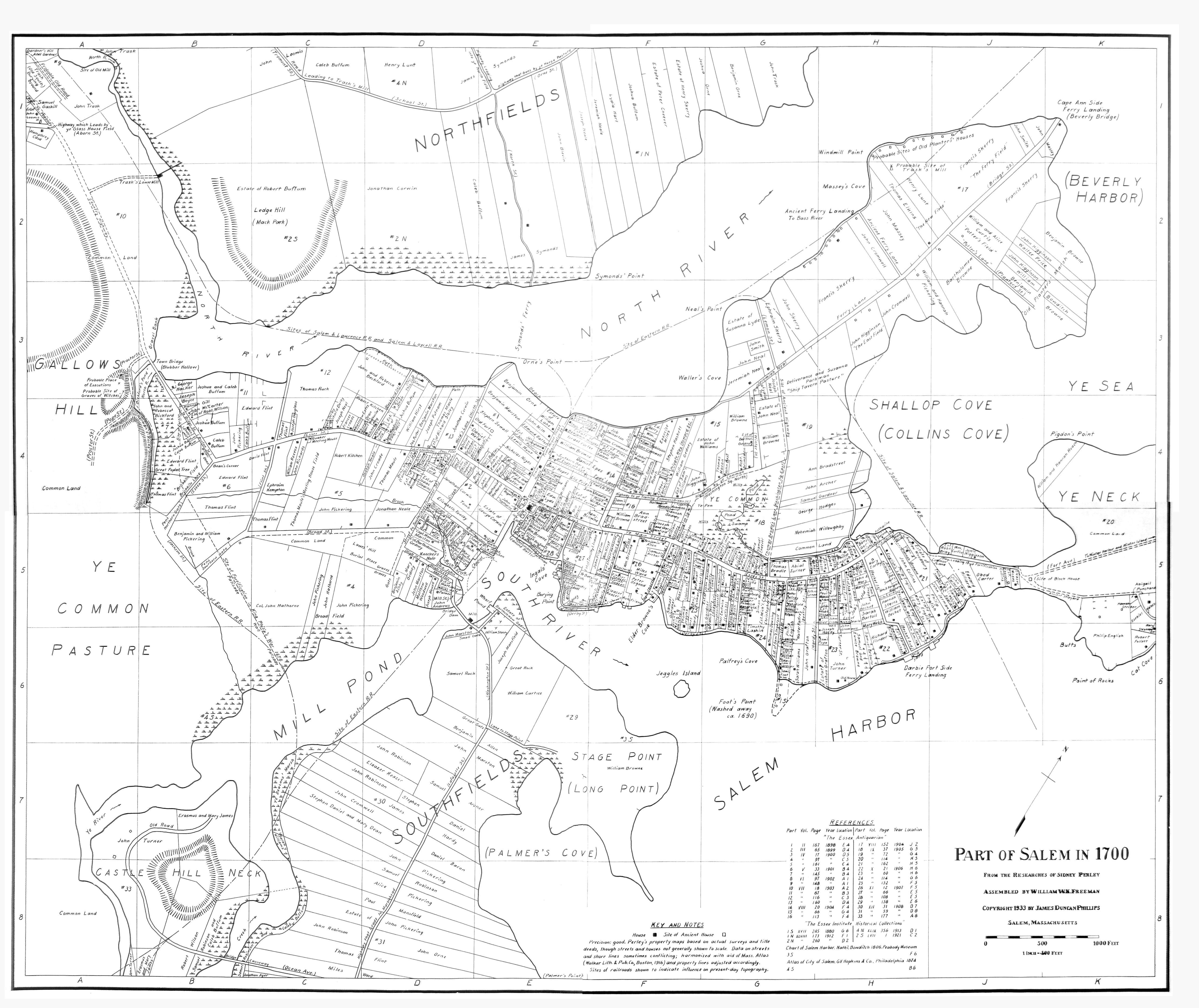 |
|||||||||||||||||
| 6:45- 7pm |
Motorcade to the Hawthorne Hotel 18 Washington Square West, Salem Since Derby St. is one-way, we'll drive down to the end and take the left onto Webb St., past Allen St. and Cousins St. (both on the left), to the intersection with Essex St. at Ziggy's Donuts and take a left at the light onto Essex St., past English St., Gerrish Place, Becket St., Carlton St., Turner St., Hardy St., Bentley St., Daniels St., Orange St., Curtis St., and Hodges St. to Herbert St. (all on the left), to where the Hawthorne Hotel's Guest Parking Lot is located. Since we'll be paying customers, we might as well park in the Hawthorne Hotel's Guest Lot at the intersection of Herbert and Essex St.! |
Click for a map to the Hawthorne Hotel!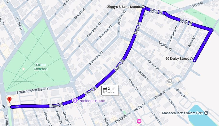 |
|||||||||||||||||
| 7- 7:45pm Pay As You Go! |
Visit the Hawthorne Hotel 18 Washington Square West, Salem We'll assemble at the Hotel's Tavern Bar and discuss the day's activities. The Hawthorne Hotel was the headquarters hotel for our 1941 Cody Family Reunion. Here, our members gathered to meet and greet, and set off to visit the site of our Philip and Martha's Beverly Homestead on Grover St. and the Dodge Row Burying Ground. It rained buckets, and the celler hole was surrounded by poison ivy, but spirits were high because this represented the culmination of a decades-long investigation of our Cody family's ancestry! We can try to guess where the Cody Family Association took their family portrait in August, 1941! |
Click for a history of the Hawthorne Hotel!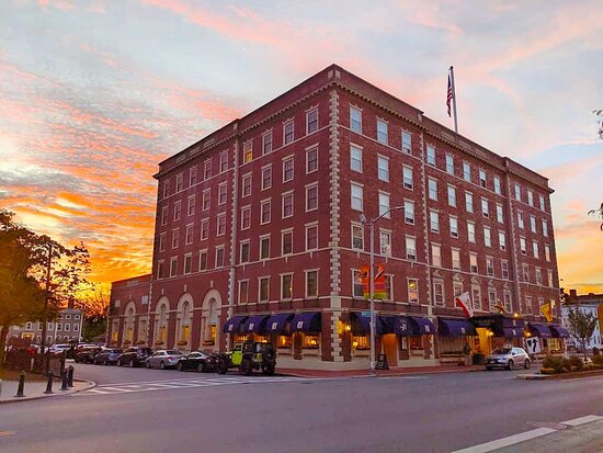 |
|||||||||||||||||
| At your leisure! |
Return to the Rockport Inn & Suites 183 Main St. (MA-127), Rockport Since we might prefer to leave the Hawthorne Hotel at different times, here are directions to the Rockport Inn & Suites! Exiting the Hawthorne Hotel's Guest Parking Lot, continue down Essex St with the hotel on your right, stop at the traffic light at the intersection of Hawthorn Bvld (on the left) and Washington Square West (on the right), take the right onto Washington Square West, past the Roger Conant Statue and the Salem Witch Museum and bear right onto North Washington Square, continue past Williams St., Mall St., Oliver St. (all on the left), and take the next left onto Winter St., continue on Winter St. past Pleasant St./Ave. and Pickman St., (both on the right), to Bridge St. (US-1A) and take the right onto Bridge St. Continue on Bridge St. (US-1A) past Lemon St. (on the left), Webb St., Arbella St., Barton St., Beacon St., Lathrop St., Cromwell St., Osgood St., Planter's St., Merrill Ave and Pierce Ave. (all on the right), and follow the US -1A North sign onto the Essex Bridge to Beverly. Once across the Essex Bridge, continue straight through the traffic light at the Water St./Front St./Goat Hill Lane intersection to the next traffic light at the fork of Rantoul St. (on the left) and Cabot St. (on the right) and take Cabot St. (MA-22) through the intersection of School St. (on the left) and Stone St. (on the right), straight through the traffic light at Bartlett St. (on the right), past Hale St. and the 1st Parish Church (on the right), follow MA-22 by taking the right onto Church St., just after Federal St. (on the left), and continue on MA-22, as Church St. turns into Essex St., continue on Essex, past Winter St. (on the left), across Dane St. at the traffic light, across Charnock St., past Munroe St., Madison Ave., Baker Ave., Peabody Ave., Bertram St., Sherman St., Lowell St., Magnolia St., Hawthorne St., Spring St., Brimble Ave., Pond View Lane, Ice House Lane, Yankee Way, Meadow Rd., to the traffic circle, where we leave MA-22 and take the 2nd exit to 128 North. Dusk is falling, so be careful and take your time. If you're on a budget, pick up some take-out along the way. |
 |
|||||||||||||||||
| 6- 10pm Pay As You Go! |
Free Time! Your Choice of; Dining on your own at one of the area's many restaurants for those who chose to skip our trip to Salem or the gathering at the Hawthorne Hotel. For those who find Salem's touristy atmosphere irritating, we sympathize. The traffic and parking as well as the stress of such a long day, may encourage some to forego this leg of our tour and relax in the quieter solace of Beverly, Gloucester or Rockport. Fear not, for we'll be happy to tell you all about it when we return to our headquarters hotel around 9pm! |
Click for a map of Rockport restaurants! |
|||||||||||||||||
|
Thursday, June 18 6:30- 9:30am Click for a map of today’s activities! |
Breakfast on Your Own Free breakfast for Rockport Inn & Suites' guests. Rockport has none of the popular fast food restaurants we're all so used to, they are located in the surrounding towns, like Gloucester. If you're looking for a local alternative, try the Lattof Farmhouse Kitchen at 205 Main St., Delisi's Red Skiff at 15 Mount Pleasant St., or the Hula Moon Cafe at 27 Mount Pleasant St. |
|
|||||||||||||||||
|
10- 11am |
ICFA General Business Meeting & Election of Officers 183 Main St. (MA-127), Rockport We'll hear the reports of our Officers, who will take your questions. As announced in our December Review, we seek a Term Limit Waiver from our attending Members to confirm the slate of nominees for office as Kevin Cody for President, Dwight Cody for Vice President and Treasurer and Allan Cody for Secretary. Then, a moderator will conduct the election of ICFA Officers for the 2026-2028 term. Floor nominations will be accepted, based on qualifications. |
|
|||||||||||||||||
|
11- 11:45am |
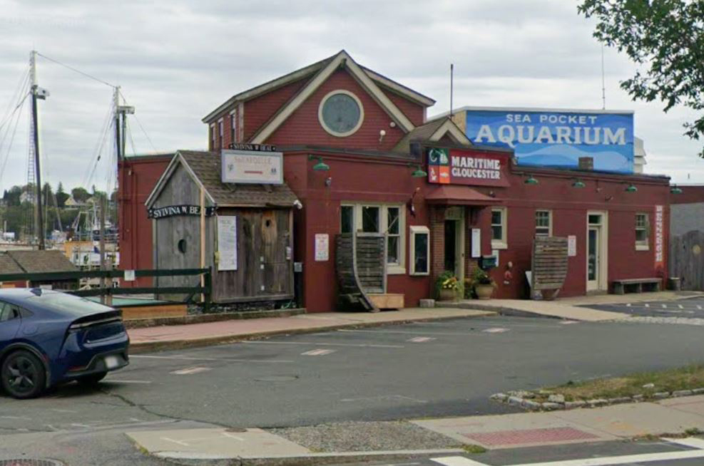
Motorcade to Solomon Jacobs Park 19 Harbor Loop, Gloucester In case of bad weather, we'll hold our Family Picnic at our headquarters hotel. Simply pick up some food and join us in the hotel's cafeteria area or firepit and we'll have a nice get-together. If the sun is out, and the weather is warm, then we may elect to follow the directions below and have our picnic near the Schooner Cruise. Exiting the Rockport Inn & Suites parking lot, turn right onto Main St./MA-127, proceed south to Gloucester for a couple of miles, look for the Crow's Nest motel on the right, then the Seaport Grille on the left, then bear left at the fork onto Rogers St., and then look for the left turn onto Harbor Loop. Located on Gloucester's Harbor Walk, Solomon Jacobs Landing & Park were named for Captain Solomon Jacobs, who fished in the early 1900s. A native of Newfoundland, he was known as the "King of the Mackerel Killers" for his ability to land huge catches of mackerel. The park features the Fitz Henry Lane House, located on top of the hill overlooking the harbor. The building is on the National Register of Historic Places and now contains offices and public restrooms. The City recently erected a statue of Lane, a brilliant painter, on the hillside. It's a good idea to bring a blanket in case the picnic tables and benches are all occupied. Alcohol consumption is prohibited in public parks for obvious reasons, so wrap your beer in a paper bag. Many of Lane's works can be found at the Cape Ann Historical Museum at 27 Pleasant St., just a couple of blocks inland from the park. |
Click for a map to Solomon Jacobs Park in Gloucester! 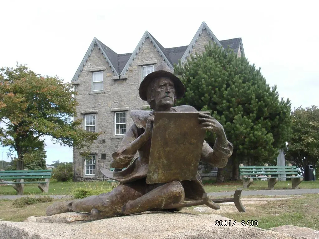 |
|||||||||||||||||
|
11:45am- 1:15pm Pick up your own lunch on the way! |
Solomon Jacobs Park Family Picnic 19 Harbor Loop, Gloucester There are a few picnic tables and park benches and in case of rain, Decklyn's is the nearest sit-down restaurant within walking distance. Whether you prefer classic hamburgers or hotdogs, Gloucester has something for you, we suggest Kings Famous Roast Beef Pizza & Seafood or Little Sister at the Cut. Order ahead with your phone and get something you really like. |
|
|||||||||||||||||
|
1:30- 3:30pm Pay As You Go! $50 Each Passenger Make Your Own Reser- vations! |
Maritime Heritage Charters Schooner Cruise 23 Harbor Loop, Gloucester In the event that the weather co-operates, we suggest you take a cruise on Harold Burnham's pride and joy, the Ardelle, a boat much like what our Philip would have served on as a mariner in the employ of Philip English. As we bob about in the waters off Cape Ann, we can imagine what it would have been like to sail out to the fishing grounds off Cape Sable and poach on the Abenaki Indians' fishing grounds before they drive us off with their war canoes! Check in at the Maritime Gloucester building to enjoy a cruise on the 'pinky' schooner Ardelle with Captain Burnham. Weather can be fickle, so be sure to bring along a warm sweater, waterproof jacket and hat! If you come early, there is plenty to see and do at Maritime Gloucester. It is the responsibility of our passengers to be present at boarding. Public sails board at sail time and we cannot hold the vessels' departure or return to the dock for any passengers not present at boarding. There is limited free parking in the lot in front of Maritime Gloucester for Maritime Heritage Charter's passengers and metered parking along Harbor Loop. There are also three metered municipal parking lots on Rogers St. within a block of the dock. All parking is on a first-come-first-served basis. |
 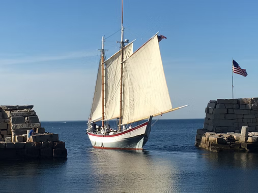 The Ardelle sets sail! |
|||||||||||||||||